A record cold day in Denver?

Possibly.

It will be close, and it may depend on how long these clouds and the rain sticks around.

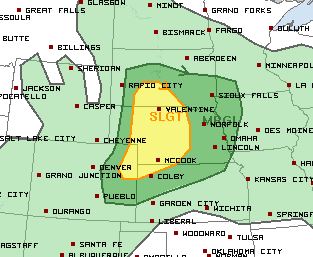
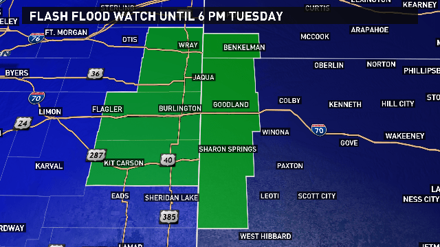
A lot of moisture is flowing into the state from the northwest. That, combined with a couple of disturbances, means a chance for showers and even thunderstorms all day today. Thunderstorms are not expected to be severe… but we certainly could see some heavy rain, especially in far eastern Colorado. In fact, a FLASH FLOOD WATCH is in effect for Cheyenne and Kit Carson Counties through Tuesday afternoon.

4_CO_Flash_Flood_Watch

The chance for rain and cloud cover the entire day could keep temperatures below 65 degrees in Denver. And 65 is currently the “Record Coldest Maximum” for the city. That record was set in 1939.

3_Record_COLD_High

Now, a couple of hours of sunshine could propel those temperatures above 65 degrees this afternoon. Where we get that sunshine makes a difference. The official temperature observations for the day are recorded at DIA. The sun may come out at DIA today, but not downtown, resulting in a warmer temperature 18 miles northeast of the city, versus in Denver itself. If that happens, the record remains in tact… a record that was originally set at 16th and Larimer in 1939.

You can argue all you want, saying this is not logical. You may be right. But the fact is, the National Weather Service and the Federal Aviation Administration has mandated that commercial airports be the origin of regular weather observations in the United States. And our commercial airport is DIA… 18 miles northeast of the city. So, unless those government regulations change, we’re gonna have to deal with it.

The POINT is we’re watching for a record cold day today, and this is all a part of a month that may be colder than average across Colorado.

The Climate Prediction Center recently released it’s outlook for August 2017. It features colder than average temperatures across Colorado.

August 2017 Temperature Outlook

And above average precipitation.

August 2017 Precip Outlook

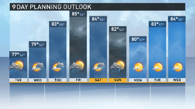
Seeing as the average high temperature in Denver this week is between 88 and 89 degrees, that below average temperature forecast is holding true… at least for the next 9 days.

3_9_Panel_Extended


Payback’s a B****

This. (Sigh)

This is the gift my younger brother got my son for his birthday. He bought it more than a year ago… fearing it would go missing from the shelves by the time an age appropriate birthday (3) rolled around.

He is encouraging the children to sneak up behind unsuspecting people and let it rip.

It, of course, has become his favorite toy. And while I've been known to giggle at a fart joke… this has been playing at all possible times of the day.

Just a couple of months ago, my brother also taught my children the joke… "Guess what? … Chicken Butt!"

Lord help me if he has no kids. Because I'm waiting, I'm keeping tally, and payback is coming.

August 2, 2017 Severe Weather Risk

080217 severe wx threat


Strong storms are possible across parts of Colorado today. The picture above shows the categorical risk for severe weather, issued by meteorologists at the Storm Prediction Center in Norman, Oklahoma. For those who are unaware, the categories for risk include: Marginal, Slight, Enhanced, Moderate and High.

Here is a quick definition of what each category means:

Convective Risk Categories Defined.JPG

You can also click here for a more in depth look at SPC products.

So, what does all this mean for the forecast for today…  Today’s risk is SLIGHT for far northeastern Colorado, and MARGINAL for locations just outside of the Denver area.

As of this posting, a cold front was sitting north of Colorado, over Wyoming. This front will push south into our state late this afternoon/evening. Showers and thunderstorms will develop ahead of the front on the eastern plains, specifically in far northeast Colorado, close to 3 p.m. As they build, they will be moving south/southeast.

Storms on our far eastern plains have enough support in the upper levels for the development of severe weather. Large hail and damaging wind will be the primary threats. However, there is also a small chance for an isolated tornado. These storms will gradually exit southeastern Colorado late Wednesday night.

For Denver and the Front Range: isolated thunderstorms are possible. However, we do not have as much upper level support for strong storms. Isolated storms have already begun to form in the foothills and mountains. These storms are moving to the southeast and contain heavy rain and lightning. They will cross I-25 late this afternoon, around 3 p.m. We will see a threat for lightning, heavy rain and small hail as storms cross the interstate.  Most of the shower and thunderstorm activity in Denver will be over by 3 a.m.

The threat for severe weather in Denver is low. However, still watch for one or two storms to become severe.

NOTE: Models are also showing a second wave of showers and thunderstorms moving through the Denver area early tomorrow (Thursday) morning. This bears some watching so see if consecutive model runs pick up on this. It could mean some slick driving conditions for commuters early Thursday.


Escape Routes – Costa Rica

You may be asking yourself, “Why is Becky talking about a vacation to Costa Rica in the middle of the SUMMER?!”

I’ll tell you why… because winter is fast approaching. I am well aware of what the calendar says: Fall begins September 22; Winter begins December 21.

But here’s a few more stats…

Denver typically sees it’s first snow by OCTOBER 18th. Denver’s average October snowfall… 4.0 inches. If you want to go extreme, the Blizzard of 1997 came October 24 – 25th. Almost TWO FEET of snow fell over that time frame.

October weather 1997

If you’re superstitious, Denver has not seen snow during the month of October for the last 3 years. That’s the first time that’s happened in Denver weather history. We’re due.

October weather

If snow is falling, then it might as well be winter. So let’s all agree that winter in Denver starts in OCTOBER, which is now only 2 months away.  By the time January rolls around, we’re right smack in the middle of winter, despite what the calendar says. And I don’t know about you, but by that time I’m ready for a warm break.

As I look at the family calendar, a January trip to Costa Rica sounds tempting. In full transparency, I have never been… but I’ve wanted to go for years. And this meteorologist doesn’t go anywhere on vacation until I’ve researched its weather. According to what I’ve found, Costa Rica is a pretty great place to be when Denver is looking mighty chilly.

Their “green season”, or winter, runs from May to mid-November. It’s called the “green season” because of all the rainfall. Costa Rica averages 100 inches of rainfall every year… with some mountain areas getting more than 25 feet. During “green season”, you’ll wake up to sunny skies with rain showers developing during the afternoon. If you like to surf, some of the largest swells come during “green season”. And full rivers make for great white water rafting. Not to mention, it’s a little less expensive to visit when there is so much rain! However, that four wheeling trip you are wanting to take might not happen due to some roads becoming impassable. Can you imagine zip lining in the rain? When rain hits you at high speeds, it burns! I don’t enjoy the feeling of small rocks pelting my skin. Constantly. And what if you want to be lazy and hang out at the beach? Not happening if it’s raining all afternoon.

That brings me back to January. It’s 5 degrees outside in Denver and you have 5 layers of clothes on to keep you warm. The Broncos are great (hopefully), but the forecast is bleak… calling for a slow warm-up back to the 30s in five days.

January Denver

Meanwhile, in Costa Rica…

January Costa Rica

It’s dry season… especially along the Pacific Coast. Temperatures along the beaches of the Pacific Coast average from 86 to 94 degrees. Average temperatures in the mountains around the central valley range from 75 to 85 degrees. A few rain showers are possible… but are brief in the afternoon or evening.

Yes, please. Maybe a quick, long weekend trip to the Pacific Coast of Costa Rica in January is just the break I need. 🙂

(NOTE: In January, the northwest part of Costa Rica gets windy as cooler air dives in from North America. And the Caribbean side of the central mountains is still rainy. Cooler air pushes across the Gulf of Mexico, collides with warm, humid air over the northeast side of the country… and results in days of rain locals call “temporales del Atlantico”.)