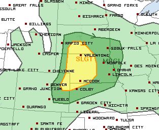
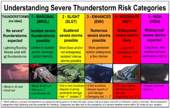
Strong storms are possible across parts of Colorado today. The picture above shows the categorical risk for severe weather, issued by meteorologists at the Storm Prediction Center in Norman, Oklahoma. For those who are unaware, the categories for risk include: Marginal, Slight, Enhanced, Moderate and High.
Here is a quick definition of what each category means:
You can also click here for a more in depth look at SPC products.
So, what does all this mean for the forecast for today… Today’s risk is SLIGHT for far northeastern Colorado, and MARGINAL for locations just outside of the Denver area.
As of this posting, a cold front was sitting north of Colorado, over Wyoming. This front will push south into our state late this afternoon/evening. Showers and thunderstorms will develop ahead of the front on the eastern plains, specifically in far northeast Colorado, close to 3 p.m. As they build, they will be moving south/southeast.
Storms on our far eastern plains have enough support in the upper levels for the development of severe weather. Large hail and damaging wind will be the primary threats. However, there is also a small chance for an isolated tornado. These storms will gradually exit southeastern Colorado late Wednesday night.
For Denver and the Front Range: isolated thunderstorms are possible. However, we do not have as much upper level support for strong storms. Isolated storms have already begun to form in the foothills and mountains. These storms are moving to the southeast and contain heavy rain and lightning. They will cross I-25 late this afternoon, around 3 p.m. We will see a threat for lightning, heavy rain and small hail as storms cross the interstate. Most of the shower and thunderstorm activity in Denver will be over by 3 a.m.
The threat for severe weather in Denver is low. However, still watch for one or two storms to become severe.
NOTE: Models are also showing a second wave of showers and thunderstorms moving through the Denver area early tomorrow (Thursday) morning. This bears some watching so see if consecutive model runs pick up on this. It could mean some slick driving conditions for commuters early Thursday.
